

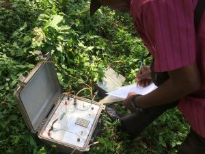
 At Shoeman Kenya Ltd, we strongly recommend that prior to drilling a borehole a hydrogeological survey is undertaken to establish the potential quantity and to give an indication of the anticipated quality of water. Hydrogeological assessment further helps in estimating drilling costs. In some circumstances additional permissions such as Coal Authority We have qualified hydrogeological assessors who after carrying out the survey analyse the findings to ascertain suitable sites for exploration of significant quantities of groundwater before carrying out any drilling exercise. This ensures the best spot is selected according to the geological data and our clients’ farm plan
Hydrogeological assessment
The hydrogeological assessment typically comprises of (but is not limited to) the following tasks:
- Ascertain the requirements of the customer, location, yield and use;
- Geological assessment, general geology, lithology and structure
- Hydrogeology, implications of the geology in terms of water bearing horizons, anticipated yield, hydraulic properties of each aquifer, groundwater flow direction, pathways and rates of flow.
- Aquifer availability, the Environment Agency’s classification of the aquifer in terms of availability of water and licence.
- Boreholes and abstractions in the catchment and region, including borehole logs and aquifer parameters (where known)
- Data collection and collation
- Groundwater quality assessment
- Catchment assessment, an understanding of the anticipated groundwater catchment
- Catchment risk assessment, and risks to yield and quality, including the potential for planned activities to result in groundwater contamination and known or expected presence, distribution, concentration and risk from existing contamination.
- Assessment of source, contaminant transport pathw
- ays and receptors for groundwater contamination
- Initial assessment of health and environmental risk
- Borehole design and recommendations